
The article “Sea-level rise induced change in exposure of low-lying coastal land: implications for coastal conservation strategies” was published.
Credits: T. Girard, photographer Conservatoire du Littoral
If poorly managed, human development that is increasingly shaping coastal areas can damage coastal ecosystems and their services, reduce the coastal landscape value, and ultimately affect food production, tourism, and coastal communities. To prevent such adverse impacts, the approach of Coastal Conservation Agencies consists in purchasing coastal land, in order to avoid its development or restore it. As coastal erosion and flooding are projected to increase with sea-level rise (SLR), SLR is considered as a major issue for coastal conservation agencies. In this study, we focus on the case of the Conservatoire du littoral (Cdl) in France which currently protects more than 2,000 km² in Mainland France and overseas, owns 13% of the coastline in France and aims to grow this to 25% by 2050. More specifically, we explore how the exposure of the Cdl coastal land heritage portfolio to flooding and erosion is projected to increase with SLR.
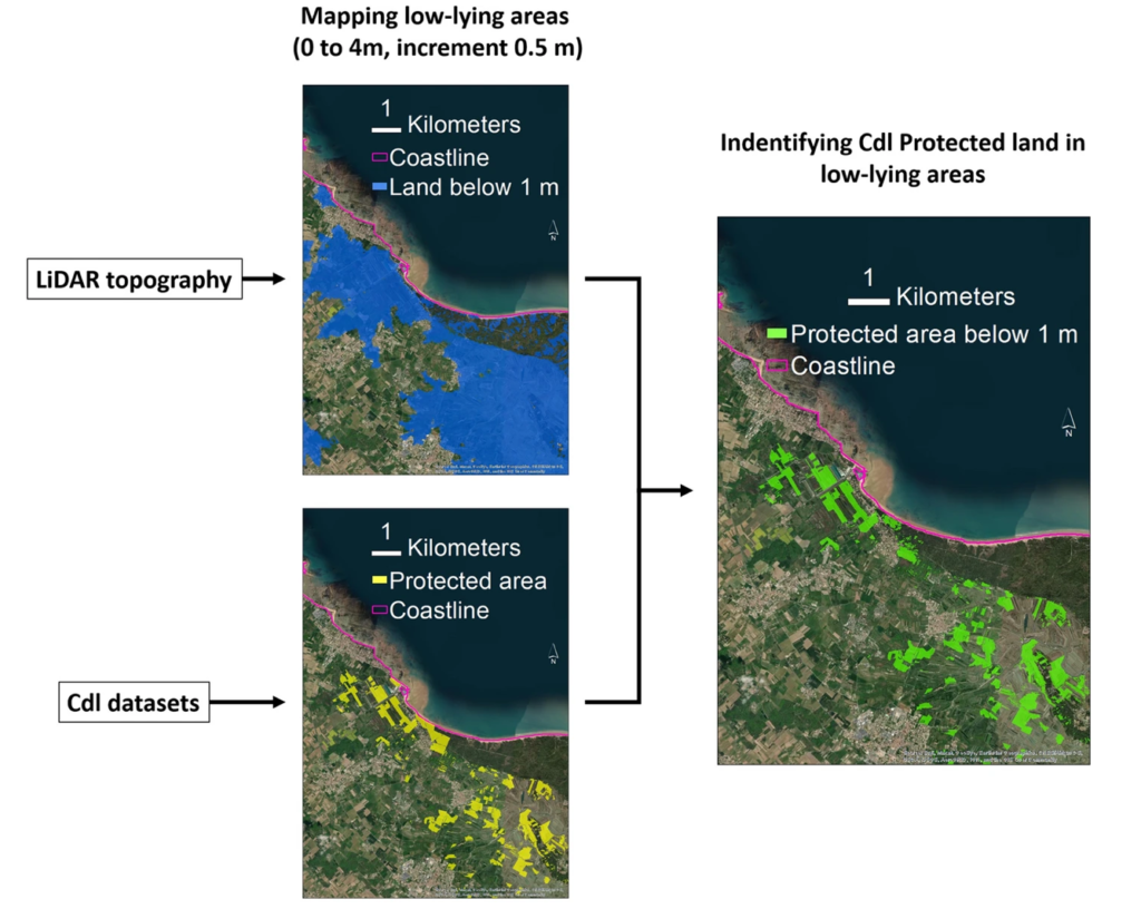
First, we quantify change in Cdl land exposure in low-lying coastal zones by identifying areas containing Cdl land whose elevation is below the highest astronomical tide today and in the future for different SLR scenarios. An example of analysis is shown on Figure 1. Second, we assess future sandy shoreline changes by extrapolating recent shoreline change trends and superimposing the effects of SLR from a simple shoreline change model. Shoreline projections are then used to quantify projected loss of Cdl land.
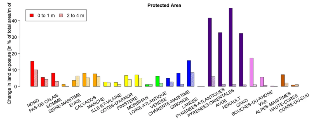
Our results show that Cdl land exposure to SLR is projected to increase by ~10% by 2100 under high impact scenario (SSP5-8.5) and 2150 for moderate scenario (SSP2-4.5). The increase in low-lying land exposure appears to be the largest along the West Mediterranean coast of France. We also find that Cdl land exposure increases more rapidly for SLR in the range of 0-1 m than for SLR in the range 2-4 m (see Figure 2). Thus, near-future uncertainty on SLR has the largest impact on Cdl land exposure evolution and related land acquisition planning. Concerning erosion, we find that nearly 1% of Cdl land could be lost in 2100 if observed historical trends continue. Adding the SLR effect could lead to more than 3% land loss.
Overall, our study confirms previous findings that achieving the aim of owning and conserving 25% of the shoreline in France will require the Cdl to consider land losses due to SLR and change its acquisition strategy to include more depth from the coast to create space for these dynamics with their land holdings.
Reference: Thiéblemont, R., Le Cozannet, G., Rohmer, J., Privat, A., Guidez, R., Negulescu, C., Philippenko, X., Luijendijk, A., Calkoen, F., and Nicholls, R.J., (2024), Sea-level rise induced change in exposure of low-lying coastal land: implications for coastal conservation strategies, Anthropocene Coasts, 7, 8 (2024). https://doi.org/10.1007/s44218-024-00041-1.
Leave a Reply