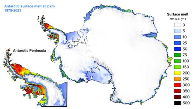
The article Higher Antarctic ice sheet accumulation and surface melt rates revealed at 2 km resolution was published in Nature Communications.
This study presents high-resolution (2 km) Antarctic maps revealing higher snowfall and surface melt than previously estimated.
Find below the main results:
- The AIS is currently losing mass through increasing iceberg discharge (D), but the mass loss interannual variability is mainly driven by surface mass balance (SMB) processes: snowfall accumulation minus surface ablation from sublimation and meltwater runoff.

- Climate models are key tools to reconstruct the contemporary and project the future AIS SMB. However, these models typically run at 25-100 km spatial resolution, insufficient to resolve e.g., mountain ranges or the steep grounding lines (i.e., land/floating ice transition).

- In our study we statistically downscaled Antarctic SMB components from the regional climate model RACMO2.3p2 at 27 km to a 2 km grid. Grid refinement enhances orographic snowfall accumulation over steep mountain ranges such as the Antarctic Peninsula.

- Integrated over the grounded AIS, this higher snowfall at 2 km increases SMB by 2% relative to the 27 km product. Although small, this SMB increase is sufficient to reconcile satellite-observed mass change (MB) from GRACE/GRACE-FO when combined to ice discharge (MB = SMB – D).

- Statistical downscaling to 2 km also enhances surface melt by 46% when integrated over the grounded AIS and floating ice shelves. Notably, melt increases across grounding lines that were not well resolved at 27 km, as is clearly visible for the Antarctic Peninsula.

- Higher surface melt near grounding lines is projected to persist until 2100 under all warming scenarios (low-end SSP1-2.6 to high-end SSP5-8.5), suggesting higher surface melt rates than previously estimated and further endangering the stability of vulnerable ice shelves.

Read more about the study in our ‘Behind the paper’ post at Nature Research Communities.

Leave a Reply